The words on your deed matter
Every piece of real estate in Mississippi exists twice: once as land you can walk on, and once as words on paper. The legal description—the language in the deed that identifies what is being conveyed—is what connects the two. A legal description is "an essential term that must be stated with specificity." Woodruff v. Thames, 143 So. 3d 546, 554 (Miss. 2014). If a document fails to sufficiently describe the land, it is unenforceable under the statute of frauds, the rule requiring land contracts to be in writing. Id. at 555.
Three primary types of descriptions
1. The Public Land Survey System
Mississippi is a public lands state. Except for land granted by foreign sovereigns before the territory became American, the federal rectangular survey, or the Public Land Survey System or "PLSS," is the foundation of every title in Mississippi. A general knowledge of this system is necessary to understanding legal descriptions in Mississippi.
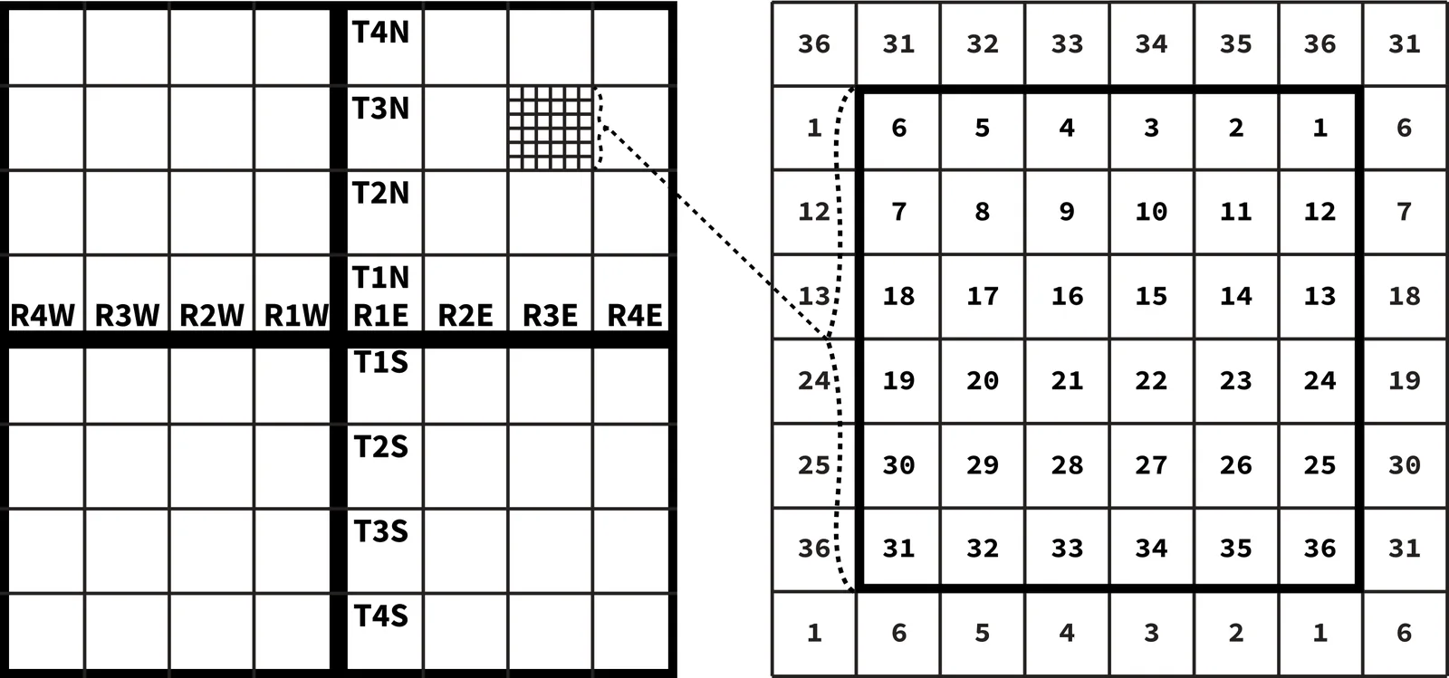
The system came out of the Land Ordinance of 1785. Under this ordinance, public lands were to be surveyed into townships six miles square, subdivided into 36 one mile by one mile square sections of approximately 640 acres each. Since an act of Congress in 1796, sections have been numbered beginning with Section 1 in the northeast corner and running west and east alternately to Section 36 in the southeast corner.
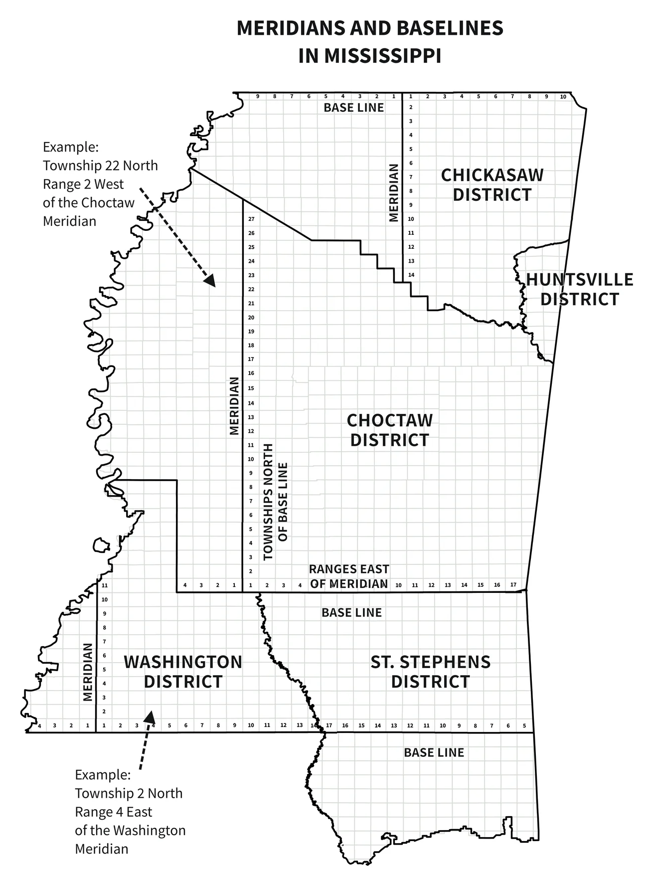
Mississippi is governed by more principal meridians than any other state except Alaska, which has the same number and is almost 14 times Mississippi's size. Five meridians control surveys across the 82 counties, because each new meridian was established to survey a newly acquired block of territory:
| Meridian | Generally governs |
|---|---|
| Washington | Southwestern Mississippi—the old Natchez District |
| St. Stephens | Southeastern Mississippi (and southern Alabama) |
| Choctaw | Central Mississippi |
| Chickasaw | Northern Mississippi |
| Huntsville | A portion of northeastern Mississippi (initial point in Alabama) |
The pattern follows the state's history. The Washington and St. Stephens meridians were laid out first, for the earliest-settled lands along the Mississippi River and the Gulf. The Choctaw and Chickasaw meridians came later. The Choctaw Meridian was established in 1821 to survey the central lands ceded by the Choctaw Nation in 1820, and its surveys later extended into the lands the Choctaw Nation ceded in 1830. The Chickasaw Meridian followed in 1833 for the northern lands ceded by the Chickasaw Nation in 1832. The Huntsville Meridian reached into northeast Mississippi from its Alabama initial point.
Reading township and range
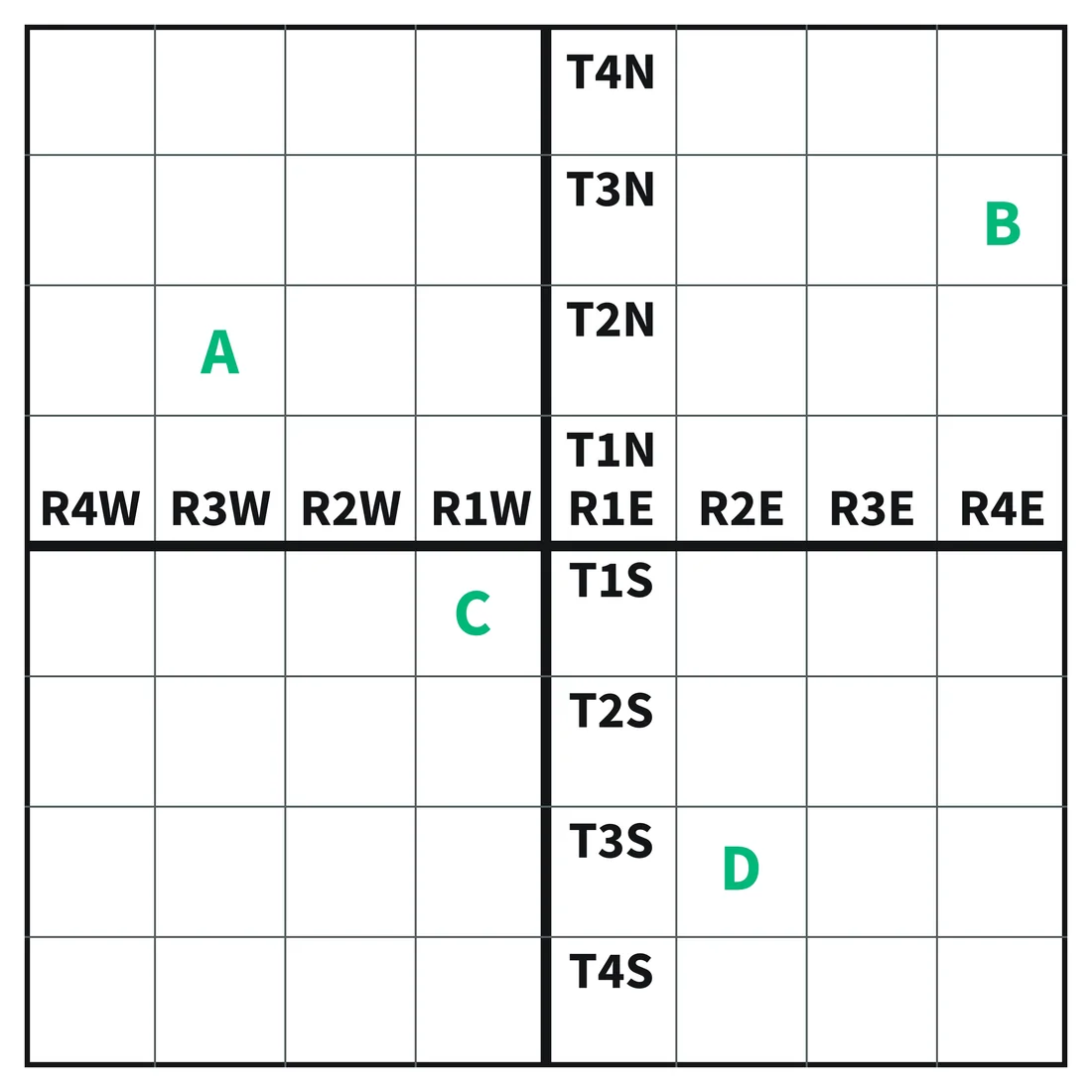
"Township 4 North, Range 2 West" (T4N, R2W) means the fourth tier of townships north of that meridian's baseline and the second column of townships west of the meridian itself.
Try it. Each square in the grid below is one township. Name the township and range of each lettered square.
Show the answers
- A: Township 2 North, Range 3 West (T2N, R3W)
- B: Township 3 North, Range 4 East (T3N, R4E)
- C: Township 1 South, Range 1 West (T1S, R1W)
- D: Township 3 South, Range 2 East (T3S, R2E)
Aliquot parts
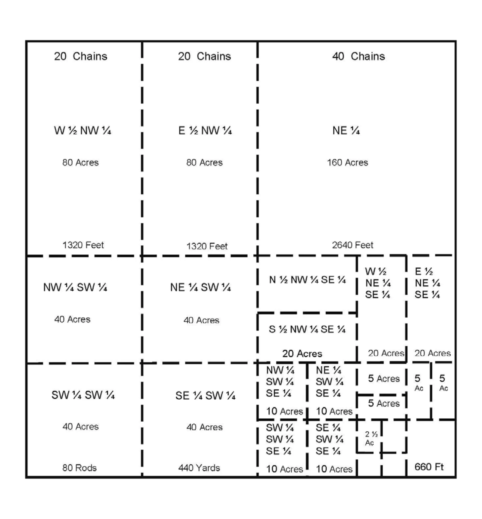
Sections are divided by halving and quartering. The pieces are called aliquot parts:
- 1 section = 640 acres
- ½ section = 320 acres
- ¼ section = 160 acres
- ¼ ¼ section = 40 acres
- ¼ ¼ ¼ section = 10 acres
Read them backward—largest to smallest—to find the parcel on the ground. For "SW¼ of the NW¼ of Section 16, T4N, R2W, Choctaw Meridian," start with the section, find the NW quarter, then find the southwest quarter of that quarter: 40 acres.
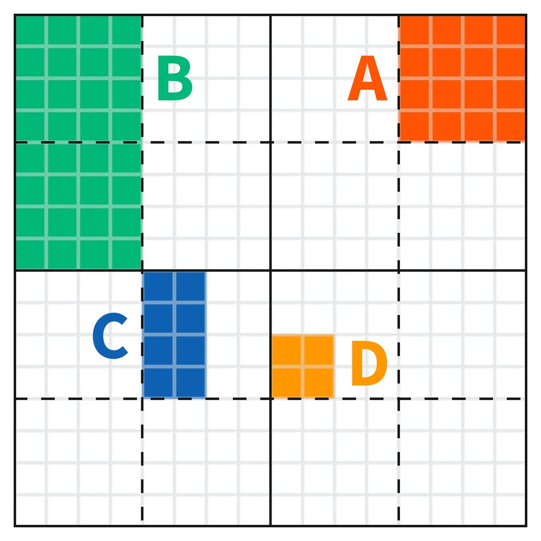
Try it. Write the aliquot description of each lettered tract in the section below, and work out its acreage. Read from the smallest piece to the largest when you write it, and from the largest to the smallest when you check it on the grid.
Show the answers
- A: NE¼ of the NE¼, 40 acres
- B: W½ of the NW¼, 80 acres
- C: W½ of the NE¼ of the SW¼, 20 acres
- D: SW¼ of the NW¼ of the SE¼, 10 acres
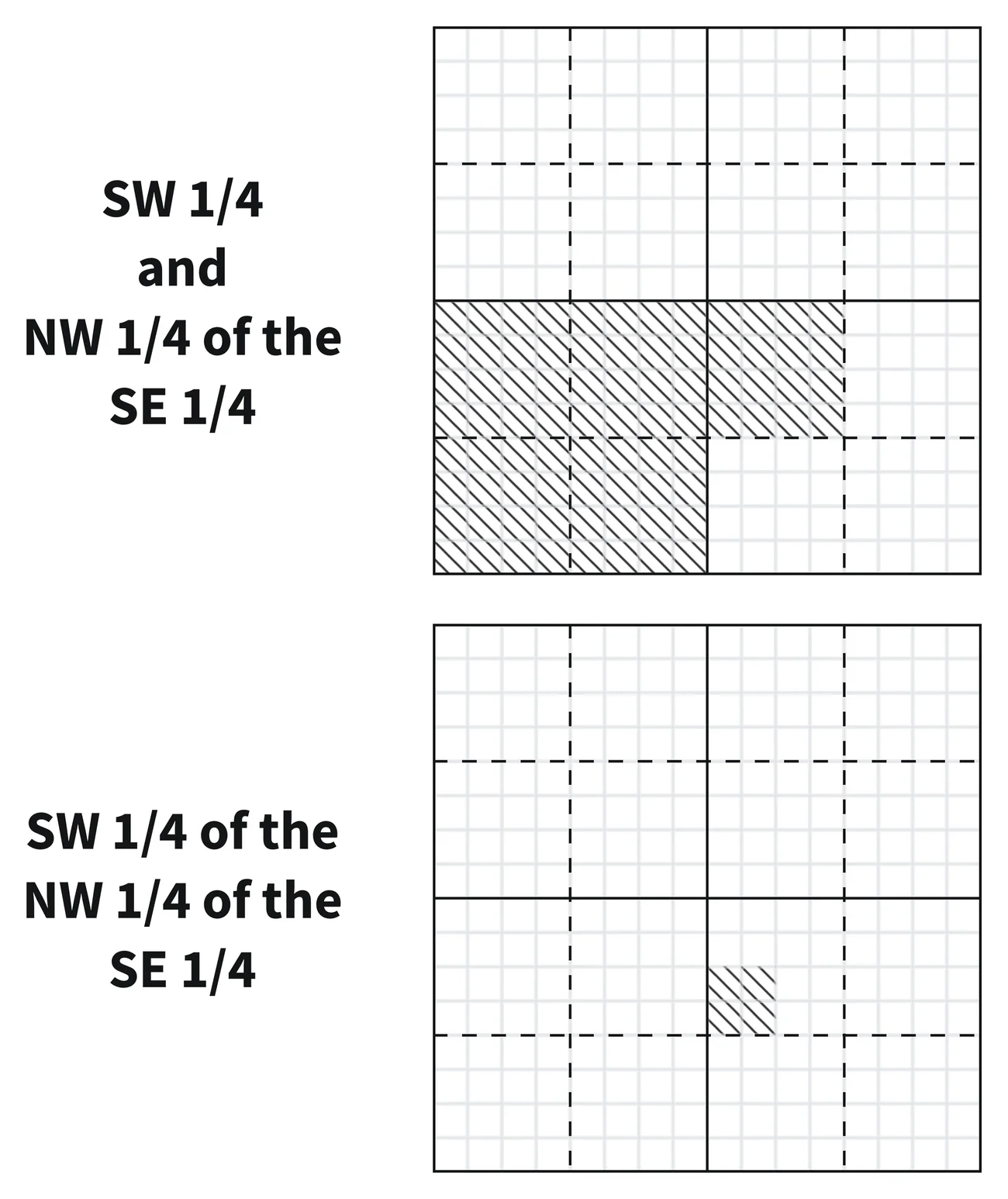
Commas can change everything about a description.
- SW¼, NW¼ SE¼ = 200 acres (the whole southwest quarter, plus the northwest quarter of the southeast quarter)
- SW¼ NW¼ SE¼ = 10 acres (one nested tract)
One comma, 190 acres. For this reason, the author encourages using the separators "of," "the," and "and" to make the description more clear. For example, the first description would be rewritten as "The SW¼, and the NW¼ of the SE¼, of Section …," and the second as "The SW¼ of the NW¼ of the SE¼ of Section …." These types of abbreviated descriptions are common in deeds in large timber transactions and other bulk sales.
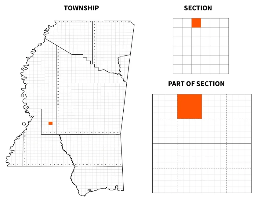
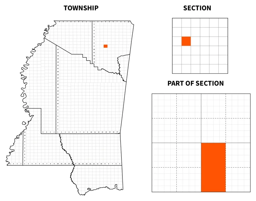
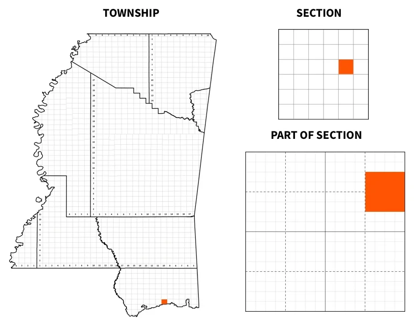
Try it. Find each of these tracts. Locate its township on a map of Mississippi's meridians, then the section within the township, then the part of the section, and work out the acreage.
- NE¼ NW¼ of Section 4, Township 4 North, Range 2 West, Choctaw Meridian, Mississippi
- W½ SE¼ of Section 17, Township 9 South, Range 4 East, Chickasaw Meridian, Mississippi
- S½ NE¼ NE¼ and N½ SE¼ NE¼ of Section 14, Township 7 South, Range 10 West, St. Stephens Meridian, Mississippi
Show the answers
Four common misconceptions about the PLSS
- Not every township has 36 full sections. Water, prior grants, and state lines produce irregular and fractional townships and government lots.
- The grid isn't square. Meridians converge toward the pole, so the survey uses correction lines, and excess or deficiency in a township is pushed into the north and west tiers of sections.
- The original survey controls—even where it was wrong. The corners and lines actually run and marked in the government survey are the true corners and lines. A quarter section is not necessarily one-fourth of a section in area; its boundaries depend on where the government surveyor did set the quarter corner, not where he should have.
- Many original corners are lost or obliterated. Re-establishing them is surveyor's work, and it starts with the original field notes and plats. The Bureau of Land Management has published manuals for properly establishing lost or obliterated corners.
2. Metes and bounds descriptions
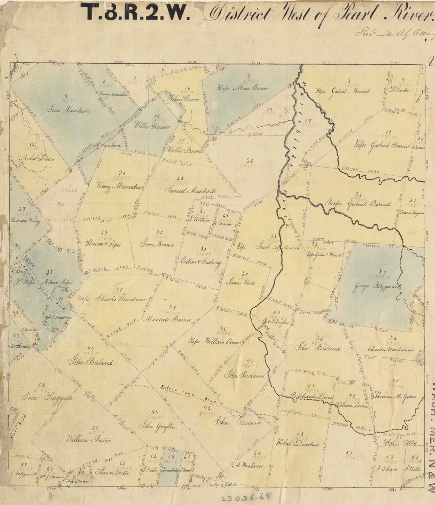
"Metes and bounds" is a broad term. It covers descriptions by natural or artificial boundaries, descriptions by reference to an adjoining owner's land, and descriptions by course and distance from a starting point—sometimes all three in one document.
Metes and bounds descriptions walk the perimeter using directions, distances, and references to physical objects and adjoining land. They are used everywhere in Mississippi for irregularly shaped tracts.
The parts of a metes and bounds description—some definitions
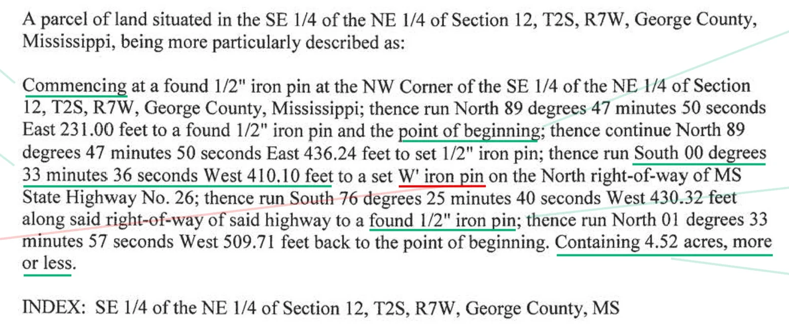
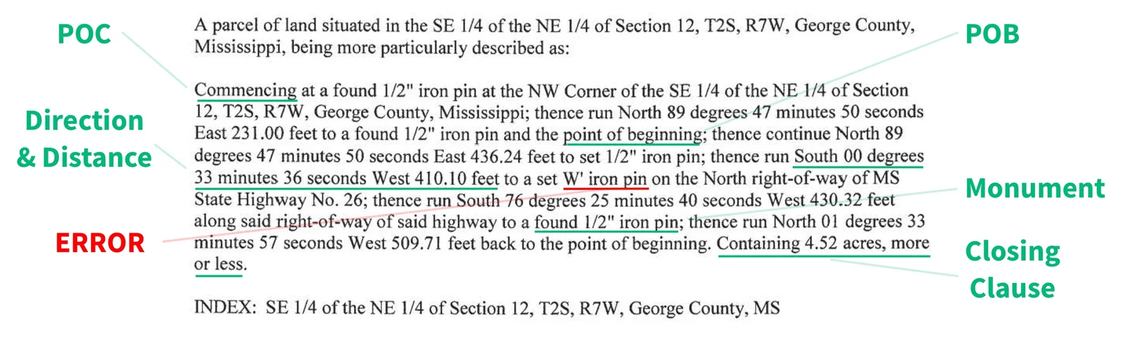
Point of Commencement (POC)—a known, findable point where the description starts, typically a government section corner or quarter-section corner. The POC is usually not a corner of the tract. It is there so that anyone can find the tract by starting from a point that can be located on the ground. A description might begin, "Commencing at the Northwest corner of Section 16, Township 4 North, Range 2 West."
Point of Beginning (POB)—the first corner of the tract itself, reached by running one or more calls from the POC. The lines run from the POC to the POB only lead to the tract. They are not part of its boundary. The boundary starts at the POB and, if the description closes, ends there.
Calls—the steps of the description, each moving from one point to the next. A call usually begins with "thence" and gives a bearing and a distance, as in "thence N 87° 29′ 45″ E 210.00 feet." A call may also name a monument or an adjoining line, as in "to an iron pin" or "along the south line of the Smith tract."
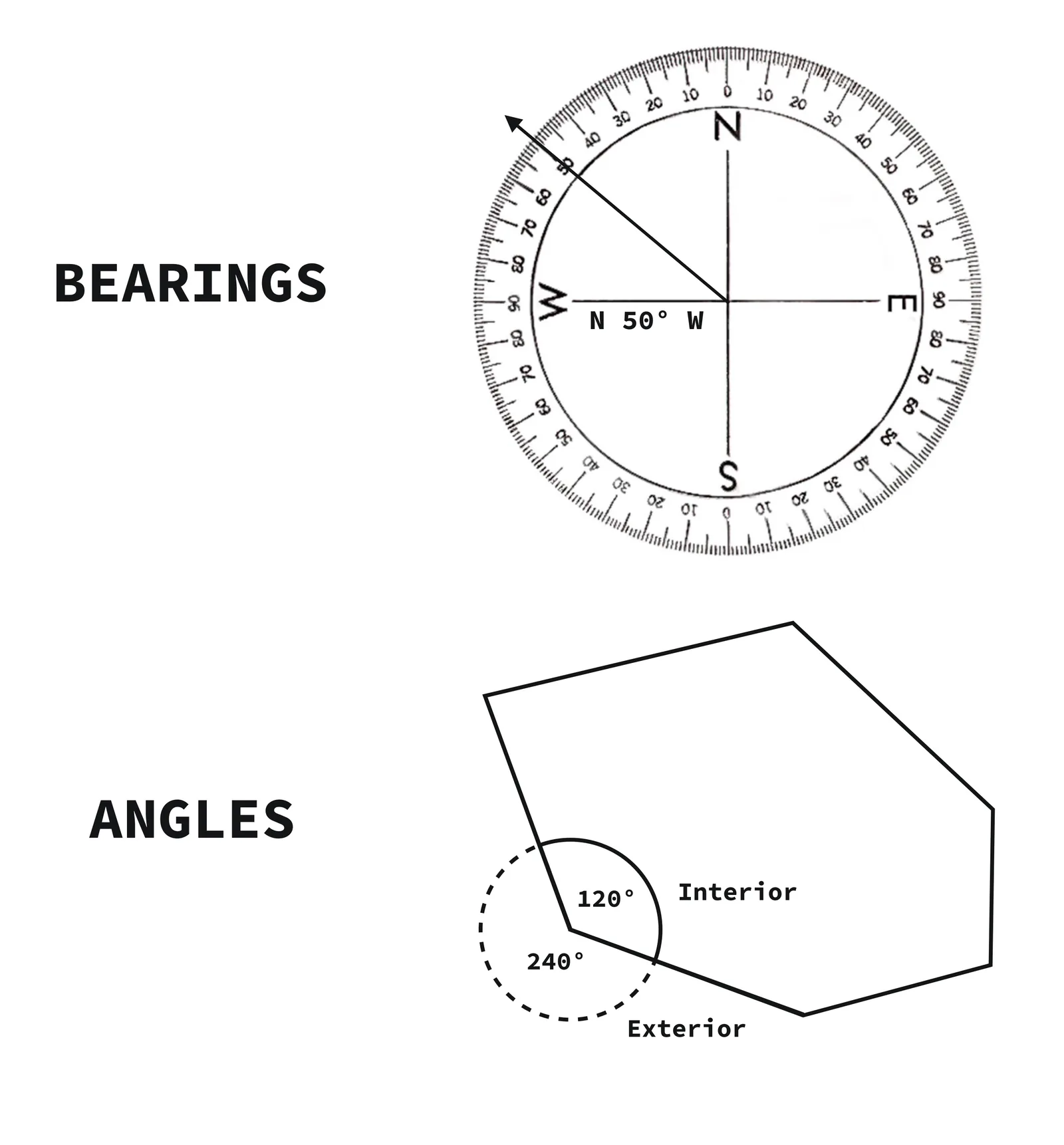
Bearings—the direction of each line, stated as a quadrant bearing. A quadrant bearing starts from north or south and turns toward east or west, never more than 90 degrees. For example, "N 87° 29′ 45″ E" means from north, rotated 87 degrees, 29 minutes, 45 seconds toward the east. Watch the units: there are 60 minutes in a degree and 60 seconds in a minute, not 100, so 87° 30′ is 87.5 degrees. Some modern descriptions use decimal degrees instead.
Distances—the length of each line, most often in U.S. survey feet. Older Mississippi descriptions frequently use chains (66 feet), rods (16.5 feet), and links (0.66 feet). A chain is 4 rods, or 100 links. A mile is 80 chains; an acre is 10 square chains, or 43,560 square feet.
U.S. Survey Foot—exactly 1200/3937 of a meter, or approximately 0.3048006 meters. Under this system, 1 meter = 39.37 inches. The U.S. survey foot is longer than the international foot by about two parts per million, roughly ⅛ inch in a mile. That difference rarely matters in a lot or a tract, but it adds up over long distances and in state plane coordinates. The federal government retired the U.S. survey foot at the end of 2022 in favor of the international foot, but surveys and records made before then still use it.
International Foot—exactly 0.3048 meters, adopted by the United States in 1959. Under this system, 1 inch = 2.54 centimeters.
Meter—the international base unit of length, defined since 1983 as the length of the path traveled by light in a vacuum during a time interval of 1/299,792,458 of a second (so the speed of light in a vacuum is exactly 299,792,458 meters per second).
Monuments—physical objects on the ground that mark a corner or a line. A monument may be natural (a stream, a large rock) or artificial (an iron pin, a fence, a concrete post). When a monument conflicts with a bearing or distance, the monument usually controls. See the priority of calls below.
Curves—curved lines, most often along a road or street. A curve is described either by arc (central angle, radius, arc length, and direction of curve) or by chord, which is the straight line between the two ends of the curve (chord bearing and distance, radius, and direction). Many surveyors will give both the description of a curve by arc and by chord, intending for the redundancy to be an error check.
A description should close
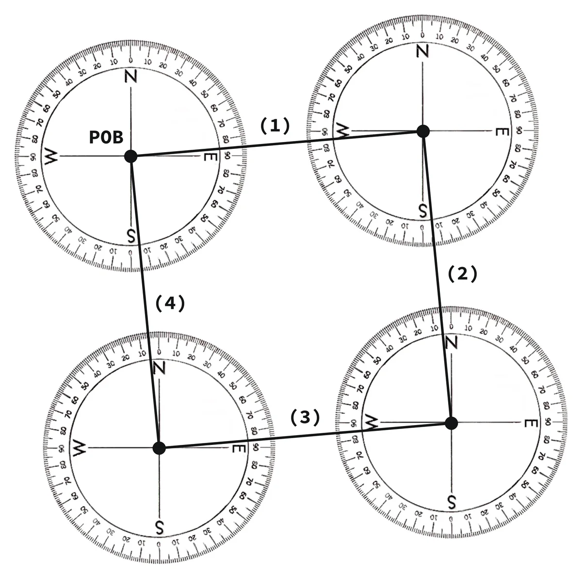
A metes and bounds description should return to the point of beginning. But a description not closing by its directions and distances alone is not automatically fatal. Courts can even supply an omitted line consistent with the parties' apparent intent, correct a manifest error in the calls—even reversing the direction of a line—and can run the calls in reverse order where doing so resolves the problem.
A court may apply the same forgiveness to a shaky starting point. An uncertain POB does not doom the description if the succeeding calls are definite enough to fix its location, or if the second corner can serve as the starting point instead. More on faulty descriptions below.
Try it. On a sheet of paper, mark a point of beginning and sketch these four calls, each starting where the last one ended: (1) N 85° E 100 feet; (2) S 5° E 100 feet; (3) S 85° W 100 feet; (4) N 5° W 100 feet to the point of beginning. If the description closes, the fourth call brings you back to where you started.
Show the answer
3. Descriptions by reference to a recorded plat—sometimes referred to as "lot and block" descriptions
Most modern residential and commercial property in developed areas is described by reference to a recorded plat. The primary elements are lot, block, subdivision name, plat book and page (or plat cabinet and slot), county and state.
Lot 42, Block 3, North Lakes Subdivision, according to the map or plat thereof recorded in Plat Cabinet Z at Slot 9, in the office of the Chancery Clerk of Madison County, Mississippi.
The strength of this system is that the complexity of the description is abstracted away in favor of brevity. And indexes for the subdivision are easily maintained separately from the sectional indexes.
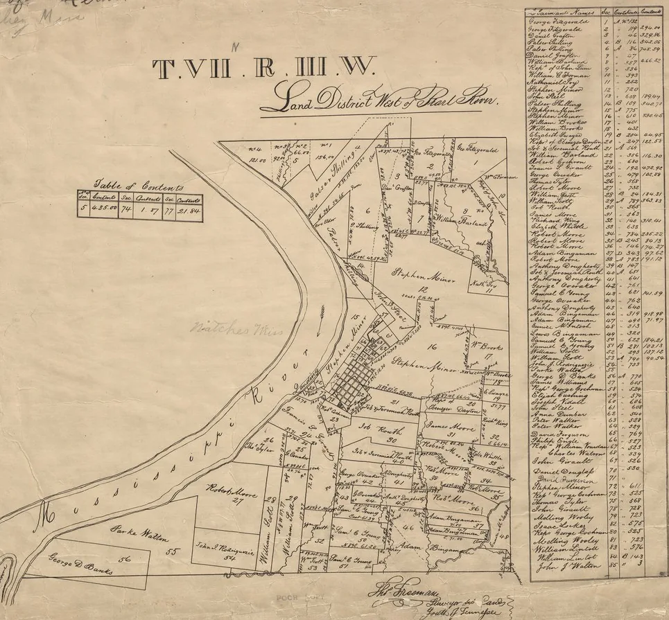
The process for identifying properties described by lot and block is simple: (1) find the plat at the record location, (2) locate the block on the plat (if the plat contains blocks), and (3) locate the lot.
To see how this works, treat the plat below as if it were a recorded subdivision plat, and find Lot 16 on it.
Show the answer
Errors in legal descriptions
Errors in descriptions do not necessarily make a conveyance invalid
The working test on whether a description is sufficient is practical: a description is sufficient if a surveyor can locate the boundaries by following it. Swartzfager v. Saul, 213 So. 3d 55, 63 (Miss. 2017); Overby v. Cavanaugh, 434 So. 2d 1365, 1366 (Miss. 1983). And a description containing inaccuracies may still be sufficient if the property could be located with some certainty. Swartzfager, 213 So. 3d at 63 (citing Stockstill v. Gammill, 943 So. 2d 35, 41–42 (Miss. 2006)).
Courts lean towards saving deeds. "It is a cardinal rule in the construction of deeds that a deed will not be held void for uncertainty of description if by any reasonable construction it can be upheld." McLendon v. Ravesies, 173 So. 303, 304 (Miss. 1937). The comment to Mississippi Title Examination Standard 5.01 builds on that: "an examiner may presume that errors, irregularities, deficiencies, and inconsistencies in a land description in the chain of title are not material unless, under the circumstances, a substantial uncertainty exists as to the identity of the land or the description fails to satisfy the minimal requirements essential to an effective conveyance." Mississippi Title Examination Standard 5.02 applies a similar test to marketability. Errors in a description do not impair marketability unless, after all circumstances of record are taken into account, a substantial uncertainty exists as to what land was conveyed or intended to be conveyed, or the description falls beneath the minimum requirements of sufficiency and definiteness. So the accurate statement is not "any error is fatal." It is that an error is fatal when it leaves the land unidentifiable.
Courts will rely on established "rules of construction" to try to save the description and identify the land conveyed. A particularly important rule is that the most certain and material parts of a description control over those that are less certain and material. One set of rules that has grown out of this principle concerns the order of priority of calls.
When calls conflict: the priority of calls
When elements of a description contradict each other, Mississippi applies a priority of calls hierarchy, from most to least important:
- Natural monuments—rivers, lakes, streams, trees
- Artificial monuments—fences, walls, houses, streets, ditches
- Courses (bearings)
- Distances
- Acreage
Standard 5.01 cmt.; Moran v. Sims, 873 So. 2d 1067, 1070 (Miss. Ct. App. 2004). "In case of conflicting descriptions, courses and distances are controlled by, and must yield to, monuments, whether natural or artificial." Ball v. City of Louisville, 56 So. 2d 4, 5 (Miss. 1952); accord Holcomb v. McClure, 52 So. 2d 922, 924 (Miss. 1951). Specific boundaries likewise control over stated acreage and fractions. Harrison v. Roberts, 989 So. 2d 930, 932 (Miss. Ct. App. 2008).
The logic behind this is that a physical object on the ground reflects what the original surveyor actually did. A number in a deed reflects what somebody wrote down, possibly wrong, possibly recopied wrong three deeds later. If the call reads "150 feet to the oak tree" and the oak is 153 feet away, the tree wins.
Fixing a bad description
If a description is unclear, the cure is to establish the correct description and get it in the land records. This can be done by a correction instrument, an agreement of the parties, a recorded affidavit where permitted, or a court decree.
Which route depends on the severity of the description problem, on whether third parties have acquired rights in the meantime, and on whether a correction instrument would materially alter the effect of the prior conveyance. A correction that materially changes things should be joined by everyone adversely affected.
If something in your deed doesn't add up—a description that won't close, an exception nobody can locate, two surveys that disagree—Maples Richey examines Mississippi titles as a regular part of its practice and can tell you what your paper says you own.
This article is general information about Mississippi law, not legal advice. Every title is different—if you have questions about a specific property, contact us.
Title image: Henry C. Daniel, Official Map of the City of Jackson, State of Mississippi (1875), detail of the Capitol Grounds and the fairground. Mississippi Department of Archives and History.